
Location
To measure distances using geographic coordinates, click the Location
Measurement  tool.
tool.
-
The application immediately begins tracking the geographic location of the cursor on the map.
-
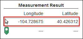
Click once in the map for a starting point. Since the cursor is at the exact location where you clicked, the latitude and longitude are the same until you move the cursor.
-
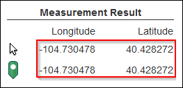
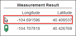
As you move the cursor around on the map, the cursor's latitude and longitude location change accordingly.
 TIP: You can still zoom and pan the map while measuring. To pan, click and hold to drag the map into position.
 -
At this point, if you click once in the map, the green Location
 icon moves to that location, which
becomes the new starting point.
icon moves to that location, which
becomes the new starting point. -
Click the coordinate drop-down to change between decimal degrees and degrees, minutes, seconds.
To stop placing coordinate points, click the Location Measurement tool to toggle it off.