
Prerequisites
The following are required before the implementation process can begin:
-
Complete an Online Service Agreement. Please contact your Account Manager for more information.
Ensure the required applications are at a supported version and license level. For the most up-to-date information about supported versions and licenses, visit the myArcFM page Supported Versions and License Levels — Designer XI Client and Services.
-
For Geometric Network (GN) implementations, the following applications are required:
-
ArcGIS Server
-
ArcGIS Desktop
-
ArcGIS Runtime
-
ArcFM Server
-
ArcFM Desktop
-
ArcFM Solution Center
-
-
For Utility Network (UN) implementations, the following applications are required:
-
ArcGIS Enterprise
-
ArcGIS Pro
-
ArcFM Editor XI: visit the myArcFM page ArcFM Editor XI Supported Versions
-
ArcFM Feeder Services XI: visit the myArcFM page ArcFM Feeder Services XI Supported Versions
-
ArcFM Solution Center
-
IMPORTANT: For GN implementations, ArcFM Server and Desktop are required because Designer XI leverages their reconciliation and post processes. Further, Designer XI uses model names and autoupdaters, much like any ArcFM implementation.-
-
Configure ArcFM Session Manager along with the Process Framework Admin Tool.
-
For gas implementations, Designer XI supports the Esri Utility and Pipeline Data Model (UPDM) with the Utility Network, and it also supports the Geometric Network.
-
For GN implementations, use your current desktop configuration to document all the autoupdaters assigned to the features that are going to be edited using Designer XI, and provide that list to Schneider Electric. Autoupdaters are configured differently when passing through ArcGIS Server, and some limitations exist. Schneider Electric requires this list upfront to best manage autoupdater implementation in a server-based environment.
-
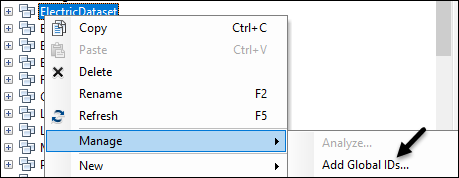
Add Global ID fields on all features that are going to be edited using Designer XI. Schneider Electric can help identify these features and enable them, if needed.
-
The feature classes in your Network Feature Service must be registered as versioned so they have editor tracking fields that contain create and update timestamps. For these to work properly, you must use the Universal Time Coordinated (UTC) standard, which is the default.
-
Know what authentication method you are using. Depending on your other applications, Schneider Electric might have already configured your authentication method during a previous implementation.
-
Know which spatial reference your company uses.
IMPORTANT: Using Web Mercator as a spatial reference for Designer XI is not recommended, as it results in inaccurate data and measurements both within the application and in any data pushed to the GIS. When choosing a spatial reference, follow these guidelines:-
Use a map projection designed to minimize errors in distance measurements. Otherwise, CU quantities for linear components such as conductors and pipes can be inaccurate, and the measure tool and precision editing tools do not function correctly.
-
For a United States customer, a state plane spatial reference containing the entire service area is a good place to start.
-
A custom projection tailored to your specific service territory produces the most accurate results.
-
Consult with a GIS expert to choose a spatial reference that is right for your organization.
-
-
Ensure Federal Information Processing Standards (FIPS) mode is turned off on devices and networks that use and support Designer XI. The application uses cryptographic algorithms that offer more enhanced security than those approved by FIPS. Despite offering a higher level of security, the algorithms are not FIPS compliant, and running applications with FIPS mode on results in network conflicts and errors.