
Create and Publish Offline Tile Package Basemaps
While offline, Designer XI uses tile packages for basemaps (backdrops). Designer XI supports both vector (.vtpk) and raster (.tpk) tile packages for basemaps. Raster tile packages are
created in ArcMap and saved as a .tpk file, and vector
tile packages are created in ArcGIS Pro and saved as a .vtpk file. Then, the files are uploaded in Solution Center > Designer > Mapping > Tile Packages and
downloaded to the clients for consumption by Designer XI.
For performance considerations, Schneider Electric strongly
recommends vector tile packages (.vtpk) instead of
raster tile packages (.tpk).
-
While online, the application automatically uses the
.vtpkfirst if it exists. This offers better performance than an online map service. If a.vtpkdoes not exist, the application automatically switches to use an online map service. -
While offline, the application can only use a
.vtpk.
While creating .vptk files, consider the following:
-
The
.vptkpackages are ultimately downloaded to the clients, so consider the size of the service area (and thus file size) when creating them to ensure there is adequate memory. There is a balance between detail and performance. -
The application can use only one
.vptkat a time, and a large service area might need to be divided into multiple.vptkareas. In this case:-
Each
.vptkmust have a unique name. -
Each
.vptkshould cover a specific area in the service territory.
-
-
A large area can take days to create.
Knowing this, you should decide which areas of your service territory
require a .vtpk.
High Precision vs. Low Precision Data Storage
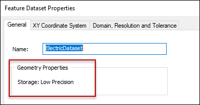
If you have a geodatabase that was created prior to ArcGIS 9.2, the data might be low precision. Replicas cannot be created with low-precision data, and low-precision Geometric Network data must be migrated to high-precision data first. If you attempt to create a replica against low precision data, you receive Error Message 000763.
-
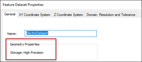
To verify the precision of Geometric Network data in ArcCatalog, navigate to the dataset and view its properties. The General tab displays the precision level:
-
If the storage is low precision, there are a few methods to convert to high precision. See the Esri documentation Migrating to High Precision.