
Good to Know
When working with Guide points, keep the following in mind:
-
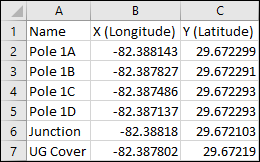
Guide points can be imported from a delimited file. It is likely easiest to work with a .csv file, and you can create and save .csv files in Microsoft Excel.
-
In your .csv file, you need a column for X (longitude) and a separate column for Y (latitude).
-
The application treats the first row as the header row. Thus, a header row is required.
-
Although optional, we recommend a Name column to help identify the Guide points. If you do not have a Name column, the application generates IDs for you on the fly.
-
The column names can be anything you want, but we recommend logical names (such as Name, X, and Y), as it makes it easier to know which columns to import.
-
Your .csv file can have other columns of information, but these are not imported with the Guide points.
-
We recommend not having empty rows in your .csv file. The import still works, but you receive error messages that it could not create Guide points from the empty rows.
-
There is no application limit to the number of Guide points (you could import thousands), but there is a usability limit. It is easier to work with a reasonable number of Guide points, so we recommend not importing superfluous points.
-
The following components snap to Guide points:
-
Conductors
-
Conduit
-
Gas Pipe
-
Generic Line Components
-
Poles
-
Surface Structures
-
-
Guide points are only visible on the Design tab. They do not appear on the Layout tab.